American Red Cross Shelter will be moving tomorrow, August 10 at 4pm from Arroyo Grande High School to New Life Community Church in Pismo Beach at 990 James Way.
Temporary Evacuation Point
Benjamin Foxen Elementary School, 4949 Foxen Canyon Rd, Santa Maria; American Red Cross personnel are on site to assist and provide information.
Cuyama Valley Family Resource Center, 4689 Highway 166, New Cuyama
FIRE INFORMATION HOTLINE
A fire information hotline has been established for both Santa Barbara and San Luis Obispo Counties
San Luis Obispo County: 805-543-2444 Santa Barbara County: 833-688-5551
ANIMAL ASSISTANCE
Santa Maria Elks Rodeo Grounds are open for large animals/livestock for Santa Barbara County Residents. You are asked to enter off Morningside Drive and enter using Gate 2.
Residents in Santa Barbara Co. needing assistance transporting large animals/livestock, call: (805) 681-4332. Residents in San Luis Obispo Co., call HEET (805) 500-0213
All County Animal Shelters continue to accept domestic/small animals at the following shelters, open until 6pm
548 West Foster Rd. Santa Maria
1501 W. Central Ave. Lompoc
5473 Overpass Rd. Santa Barbara
Santa Ynez Human is accepting domestic pets & small animals until 5pm: 111 Commerce Dr. Buellton
8/10/25, 7:14PM
Slight change in containment, up 1% to 33 percent and acreage is now 118,068
8/10/25 Update at 3:10PM
New containment number has been released; the fire is now 32% contained with acreage now at 117,524
Below is the community meeting, in it’s entirety that took place today at 2pm in Santa Margarita
8/10/25 Update 12:45PM
Focus remained of fire crews improving and strengthening existing control and containment lines; any slopovers that existed from yesterday were back within the established control lines.
Currently, the fire is still present in the Garcia Wilderness, specifically in the southern edge of the Machesna Mountain Wilderness and the movement is going towards the Huasna valley and Pozo. Challenges remain for firefighting efforts in the wilderness terrain due to inaccessibility by foot or by fire trucks. Key areas that will remain a focus for crews will be: Avenales Ranch Road, Salinas River Bed, Hi Mountain Road, Salt Creek and Huasna River.
While the most activity is seen on the north end, fire crews still have really good handle on the southern end of the fire in the San Rafael Wilderness. Crews continue the work of carefully monitoring any hot spots and they also continue to strengthen and reinforce control to prevent any escape of the fire from going beyond the established perimeter lines.
Weather: Hot and dry conditions will persist across the incident today. Afternoon temperatures will climb into the 90s to 104 while humidity drops into the teens, down to the single digits. Northwesterly, upcanyon winds can be expected this afternoon with gusts around 20 MPH.
Hot and dry conditions will continue into early this week. Although no significant wind events are expected after today, the hot and dry conditions will continue to produce very elevated fire weather conditions. Temperatures look to cool down after Tuesday.
Personnel: 3,935 Engines: 290 Hand Crews: 82 Dozers: 145 Water Tenders: 53
Here is a video of today’s operational update from the Los Padres National Forest Service
2:20pm Update 8/9/25
Acreage has been increased to 111,555 acres with containment still steady at 21%.
A note regarding the shelter location at Arroyo Grande High School: that shelter will be moving beginning tomorrow, Sunday, August 10 at 4:00 pm, the American Red Cross evacuation shelter at Arroyo Grande High School will be moving to New Life Community Church in Pismo Beach. Address is 990 James Way, Pismo Beach, CA.
Saturday Morning, August 9 Update
Video regarding the Fire Behavior of the Gifford Fire
Overnight, the fire’s behavior went further into the rugged terrain of the Garcia Wilderness, now threatening the Machesna Mountain Wilderness; this was due in part to the two large fire columns from yesterday. Crews continued to reinforce control lines from Avenales Ranch Road, the Salinas River to Hi Mountain Road with the goal to prevent the fire from spreading beyond its current territory in the Garcia Wilderness.
In the northeast side of the fire between Pelados Road and Pilitas Mountain, containment was successful of the fire growth that occurred yesterday located south of major power transmission lines. With a new slopover, which is when the edge of the fire crossed an already established control line, fire crews’ top priority for today will be to prevent the fire from spreading into the Machesna Wilderness. Dozer and hand crews will take part in connecting new control lines from the Madre Fire burn scare to the Los Machos Hills while continuing to monitor for any new threats to key facilities.
Firefighting tactics continue on the south part of the fire in the San Rafael Wilderness advancing handline construction with support from aircraft water drops. They’re also continuing to build contingency fire lines and maintaining Sierra Madre Road.
In the area of the fire that is impacting Buckhorn Ridge to Sisquoc, work is being done to reinforce existing lines while mopping up interior hot spots.
Crews want to reinforce that their primary focus is to continue protecting communities, infrastructure and critical values that are at risk. They continue to maintain and enhance containment lines, and using aircraft to cool hot spots in steep terrain that may not be accessible by foot or fire trucks.
Weather: Hot and dry conditions will persist across the incident today.Afternoon temperatures will climb into the 90s to 102 while humidity drops into the teens, down to the single digits. Southwesterly, upcanyon winds can be expected this afternoon with gusts around 20 MPH. Hot and dry conditions will continue into early next week. Although no significant wind events are expected, the hot and dry conditions will continue to produce very elevated fire weather conditions.
Evening Update – Friday, August 8
This afternoon, two large smoke columns appeared from the fire. The larger column on the northwestern side of the fire was in the same as area that crews had been tackling over the past 48 hours. The fire did officially make its way into southern boundary of the Garcia Wilderness. Meanwhile, fire crews continued their work of extending control lines from Avenales Ranch Road in the Salinas River area to the northeast. Hi Mountain Road to the north and west as well as the Huasna River north of Huasna and will continue on through the night and into tomorrow.
For the second large plume smoke seen over the northeast corner, that was located between Pelados Road and Pilitas Mountain just south of the large power transmission line and occurred when wind conditions mixed with terrain aligned just right. Air tankers dropped retardant to slow the spread of the fire in this location and activity was then slowed considerably.
In the San Rafael Wilderness, the south end of the Gifford Fire, work continued throughout the day making great progress on hand lines connecting them with existing control lines. A reconnaissance flight that took place in the middle part the day confirmed minimal activity of the fire and hot spots both on the east and west parts of the fire.
The Los Padres National Forrest have issued temporary closures for the sake of public safety and natural resources from today, August 8 until February 8 of next year. This closure does include the entire Santa Lucia Ranger District as well as a portion of the Mount Pinos Ranger District. More information can be found here
Weather: Hot and dry conditions will continue across the area through early next week. Temperatures will climb into the 90s to around 100 degrees while humidity drops into the teens and single digits. With typical diurnal winds anticipated, elevated fire weather conditions can be expected into early next week.
Personnel: 3,431 Engines: 267, Hand Crews: 75, Dozers: 142, Water Tenders: 53
Fire officials held a public meeting about the fire at Branch Elementary School Friday night in Arroyo Grande. 970 School Road. You may view the recording of the meeting here
11:36AM Update 8/8/25 – Gifford Fire Morning Update
Following the rapid growth of the fire that took place yesterday, minimal growth was proven overnight on the northwest corridor of the fire where it had started going into the Garcia Wilderness. The weather conditions overnight were at advantage of firefighting efforts; a temperature inversion set in which helped with trapping smoke and cooler air near the ground. When temperature inversion occurs, it also holds in moisture and reduces the wind. There was more activity though of the fire in the Pine Ridge area above the inversion layer where conditions remained drier and warmer.
For today, crews will continue monitoring and creating secondary control lines between Pine ridge and the nearby power line corridor in that area. This will help control the new growth that took place yesterday in the northwest side of the fire perimeter.
Continued mop up work and patrol operations will occur on the east and west sides of the fire; most of the fire on this side is holding from the Madre fire burn scars on the west side and then with the containment lines on the east.
To the south, fire crews will continue to secure that edge of the fire by building more handlines to connect with already existing control lines.
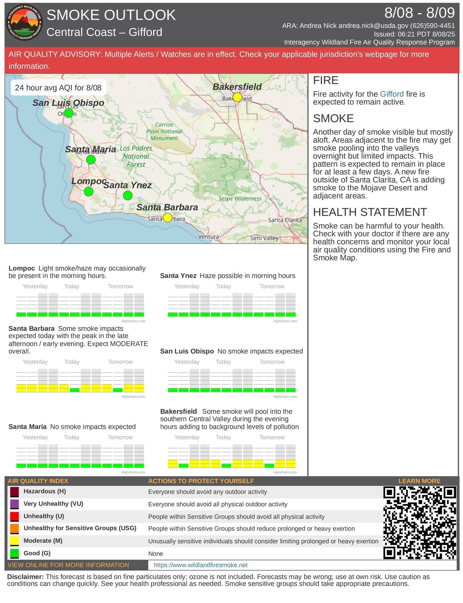
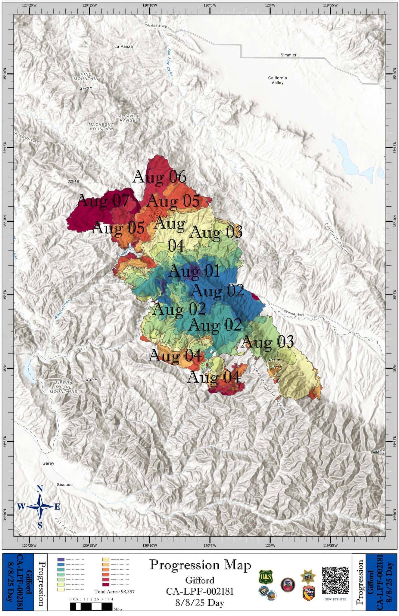
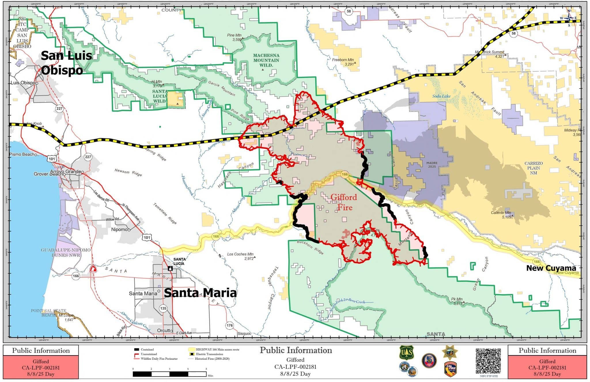
Weather: Hot and dry conditions will persist across the incident today. Afternoon temperatures will climb into the 90s to around 100, while humidity drops into the teens. Southwesterly, upcanyon winds can be expected this afternoon with gusts around 20 MPH. Very warm, and dry conditions will continue into the first half of next week. Below are graphics courtesy of Los Padres National Forest.
8/7 4:15PM UPDATE – NEW SAN LUIS OBISPO CO. EVACUATION ORDERS/WARNINGS
The following zones in San Luis Obispo County have been placed under evacuation ORDERS
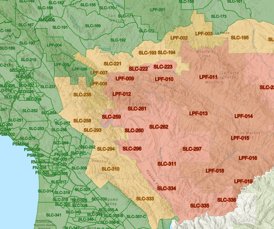
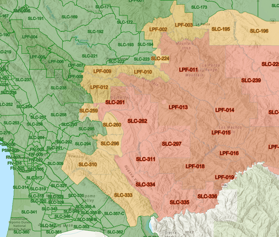
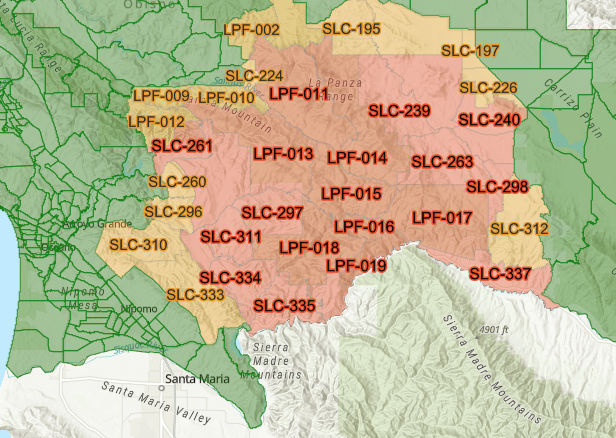
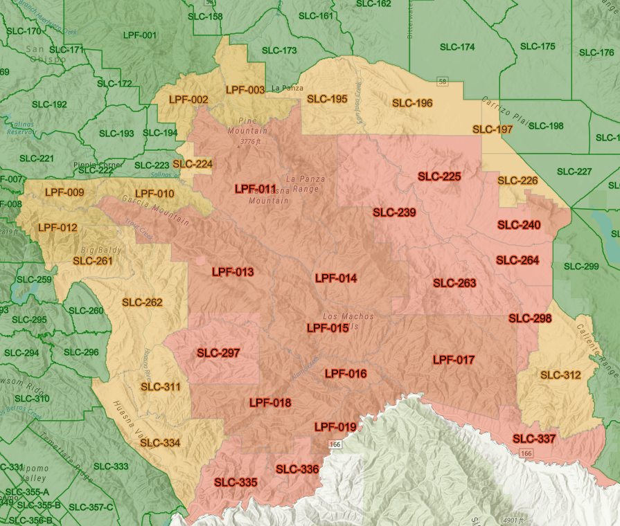
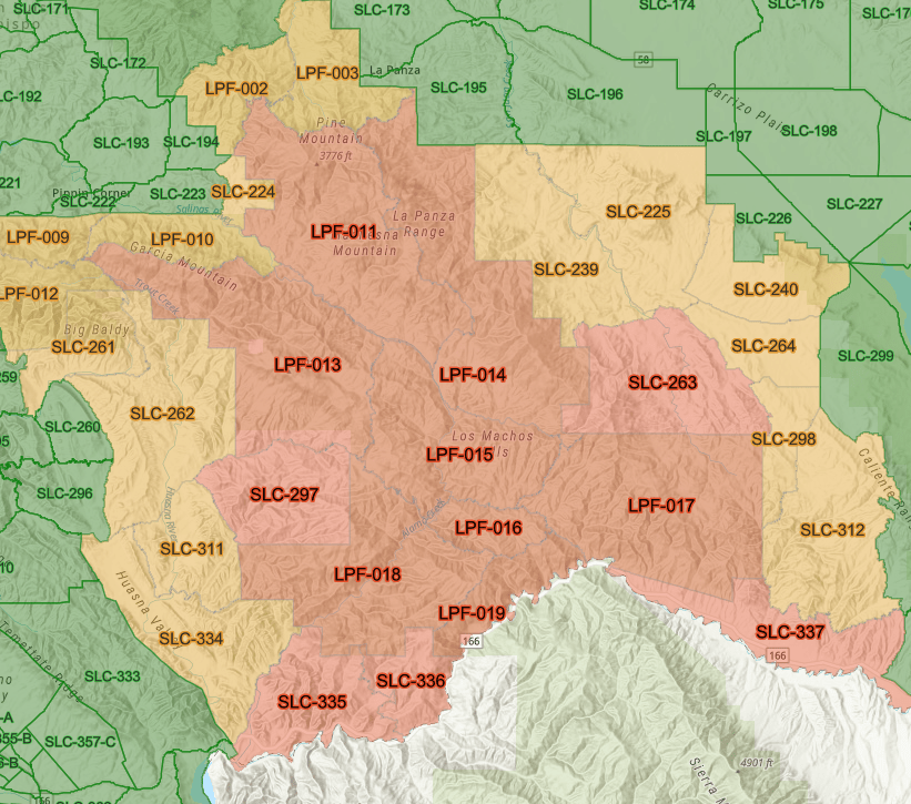
San Luis Obispo County – Evacuation Orders have been expanded to include Zones: LPF-009, LPF-012, SLC-259 (includes Lopez Lake area), SLC-260, SLC-296, LPF-010
The following areas have been placed under an EVACUATION WARNING:
San Luis Obispo County’s Office of Emergency Management has announced that Arroyo Grande High School is now open as an evacuation shelter for those affected by the Gifford Fire. Pets are welcome as well. For questions, please reach out to (805) 543-2444
8/7 1:55PM Update
New road closures have been issued
Huasna Townsite S at Huasna/Huasna E
Hi Mountain Rd at Lopez Dr
Huasna Rd has been restricted to residents only
8/7 10:15AM Update
San Luis Obispo County Evacuation Zone, SLC-259 is now under an EVACUATION WARNING.
Courtesy: prepareslo.org
8/7 Morning Update
Gifford Fire officials will host a community meeting in Santa Maria tonight at 7 PM to provide an update on the current situation and address questions. The meeting will be held at the Santa Barbara County Fire Station 23, 5003 Depot St., Santa Maria. It will also be broadcast virtually on YouTube and Facebook.
A public meeting will also be held in the Huasna area tonight; the time and location is currently to be determined. We will provide an update once we hear back.
8/7 Morning Update
Overnight, winds had exceeded 30 MPH for over and hour which moved the fire further towards Huasna and Willis Ranch. Meanwhile, spread of the fire was more active between Pine Ridge and Haystack Canyon. With this, officials ordered new evacuation orders west of these areas in San Luis Obispo County. Other parts of the Gifford Fire saw minimal activity.
Primary areas of focus for today will continue to be west of Pine Ridge and Haystack Canyon; winds are forecast to be in an northwesterly direction. On the north part of the fire, crews will continue work on direct attacks along Avenales Ranch Road in addition to working on contingency lines further north.
8/7 8:30AM Update
At approximately 5am this morning, certain evacuation warnings for San Luis Obispo County were upgraded to orders and more zones placed under an evacuation warning
Upgraded to evacuation order:
SLC-262
SLC-334
SLC-311
SLC-261
Added to evacuation warnings:
SLC-333
SLC-310
SLC-296
SLC-260
Courtesy: Prepareslo.org
8/6 11PM Update
Firefighters still battled the northside of the fire which did prompt new evacuation orders as well as warnings for the San Luis Obispo side of the fire. The most active part of the fire was spreading northwest of the La Panza Range towards the Machesna Wilderness. Crews continued to fight this end of the fire, others were working on scouting additional contingency lines, further north.
Meanwhile on the west side of the fire, officials report minimal fire activity and on the south, handlines were being built in the rugged, steep terrain the Sierra Madre Mountains. East side of the Gifford fire saw very little fire activity today.
Overnight, crews will continue monitoring control lines and deepen them as well.
8/6, 5:21PM – Acreage has been increased to 91,250. Containment remains at 9%.
8/6 5:10PM NEW SAN LUIS OBISPO CO. EVACUATION ORDERS, WARNINGS
San Luis Obispo County – Evacuation Warnings have been expanded to include Zones: SLC-195, SLC-196, SLC-197, SLC-226 –
San Luis Obispo County – Evacuation Orders have been expanded to include Zones: SLC-225, SLC-240, SLC-264, SLC-298, SLC-239
8/6 11:25AM NEW EVACUATION ORDERS
Evacuation Orders have been expanded to include Zones: LPF-011, LPF-013, SLC-297
Evacuation Warnings have been expanded to include Zones: SLC-224, LPF-002, LPF-009, LPF-010, LPF-012, SLC-261, LPF-003
8/6 11AM Update
Los Padres National Forest Service releases their morning update.
Winds last night subsided after sunset which gave relief to the north side of the fire which was growing more rapidly. Additionally on the north side, crews succeeded in building containment lines near transmission lines which yesterday was being threatened by the fire.
No movement was reported on the eastern side of the fire where flames intercepted the recent burn area of the Madre Fire.
For the south side of the fire, crews completed a build on a contingency line to Schoolhouse Ridge that was “two dozer blades wide”.
Today’s operational priorities will be on the northern part of the fire and east of Huasna Valley in the northwestern quadrant; strengthening and improving containment lines. For Buckhorn Ridge and Pine Canyon areas, assessments of this area for structural defense will be worked on as well as continuing improvements of containment lines in this area.
Weather for today, temperatures will be in the upper-80s to high-90s with areas of smoke. Relative humidity is expected to be around 10% with winds gusting up to 15 to 20 mph. The warming and drying trend is expected to continue until the weekend. Thursday could see temperatures into triple digits, increasing fire behavior.
A reminder that a community meeting will be held this evening at the Cuyama Valley Recreation District, 4885 Primero Street, New Cuyama, hosted by fire officials.
6:15PM 8/5 – Containment increases to 9%
4:30PM 8/5 – Acreage has been increased to 82,932
8/5/25 11:25AM UPDATE
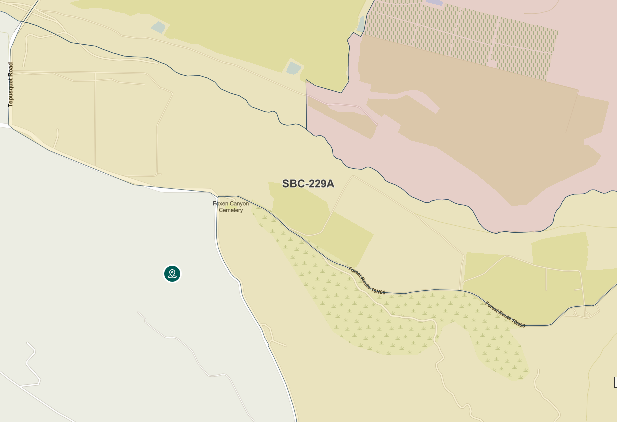
Santa Barbara County Zone SBC 229-A is now under an evacuation WARNING. This area includes:
NORTH OF Foxen Canyon Rd/Forest Route 10N06
SOUTH OF Sisquoc River
EAST OF Tepusquet Rd
WEST OF Forest Route 10N06
8/5/25 11AM UPDATE
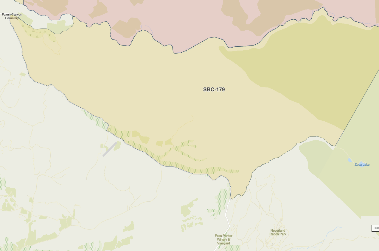
Santa Barbara County Zone SBC-179 is now under an EVACUATION WARNING with areas including
NORTH OF: Foxen Canyon Rd/Zaca Lake Rd
SOUTH OF: Sisquoc River
8/5/25 10:20AM Update
Firefighters maintained containment lines along the west side of the Gifford Fire along Highway 166, however, on the north side fire officials say that the fire did cross Alamo Creek. Dozers were rerouted by overnight operations from containment lines along the north side of Highway 166 to working on a new route along a transmission line road, building containment lines which still is ongoing. Fire activity on the east side has mainly been stable which overlaid into the recent Madre Fire burn area.
Today’s operations for fire crews are to continue working on the Alamo Creek area and along the transmission line route on the north side. They will also continue to build contingency lines both on the north and south sides. There is still a concern for structural protection. To help with this and the continued fire fight, a secondary base camp should be operating by tomorrow, Wednesday, which will reduce the travel time for crews and is closer to fire lines.
Direct Relief will be hosting a N95 mask distribution event in Buellton for community members who are impacted by wildfire smoke. Masks are free of charge, limit two per person.
N95 masks will also be available for self-service pickup at two additional locations in Santa Barbara County.
– Staffed Distribution Event (Buellton):
Monday, August 4, 2025 | 12:00 PM – 5:00 PM Tuesday, August 5, 2025 | 12:00 PM – 5:00 PM
Hitching Post 2 Restaurant: 406 E Hwy 246, Buellton, CA 93427
Additional Pick-Up Locations (Self-Service):
Santa Barbara: Santa Barbara Public Library – Downtown Branch: 40 E Anapamu St, Santa Barbara, CA 93101
Goleta: Direct Relief Headquarters: 6100 Wallace Becknell Rd, Goleta, CA 93117
Fire information hotlines have been setup for San Luis Obispo & Santa Barbara Counties, respectively. Please find those numbers above under the “Fire Information Hotline” tab.
8/4/25 – 3:45PM Fire Operations Update from Los Padres National Forest
8/4/25 9:45AM UPDATE
New evacuation WARNINGS have been issued for zones on the San Luis Obispo County side of the fire. This evacuation WARNING includes zones: SLC-311, SLC-312, and SLC-334
An update on the fire is below.
Overnight, fire crews made significant progress on the north side of the fire constructing dozier lines that overlaid with the Madre Fire lines. Containment lines were established in the Cuyama Valley to keep the fire on the Sierra Madre Ridge. On the west side of the fire, additional dozier crews worked on containment lines in the Iron Ox Ranch area and then worked their way east towards Aliso Creek.
Crews anticipate today being another active day as the fire aligns with topographical features with grass and brush-covered hillsides. They’ll continue to maintain and improve containment lines on the north side which will help with the fire not moving towards the Machesna Wilderness and in the meantime, working to keep fire the Sierra Madre Ridge, protecting structures in the Schoolhouse and Cottonwood Canyons.
Weather conditions:
For today, mostly sunny and smoky conditions are expected. Afternoon temperatures are predicted to reach the mid-80s to lower 90s, with relative humidity dropping to between 15% and 25%.
Diurnal winds are anticipated, which may increase fire activity this afternoon. A warming and drying trend is expected to continue from Wednesday through next weekend.
8/3/25 7PM UPDATE
Containment has been downgraded from 5% to 3%
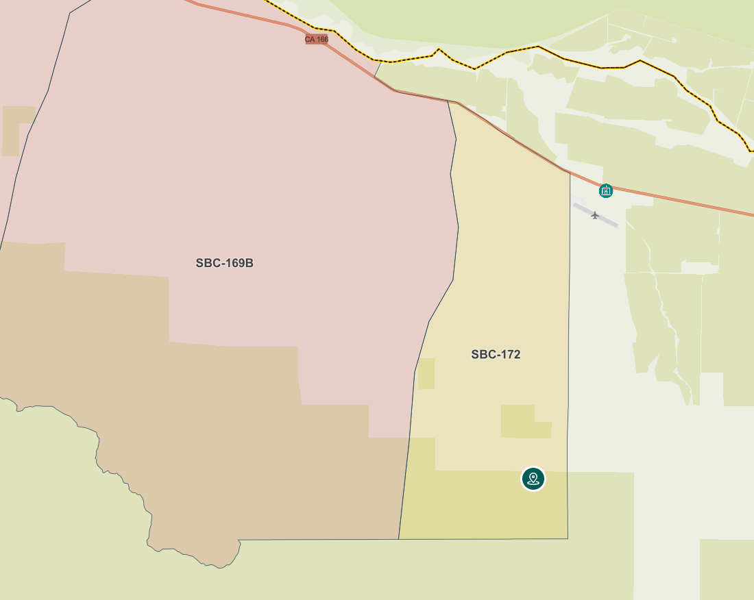
Santa Barbara County Evacuation Zone SBC-172 is now under an evacuation warning. This area includes: Aliso Canyon/Perkins
NORTH OF Carrisa Hwy
SOUTH OF Highway 166
EAST OF Aliso Canyon Rd
WEST OF Perkins Rd
A very surreal photo below shows dusk over a very smoky area of the Gifford Fire atop Plowshare Peak (courtesy: AlertCalifornia/PG&E)
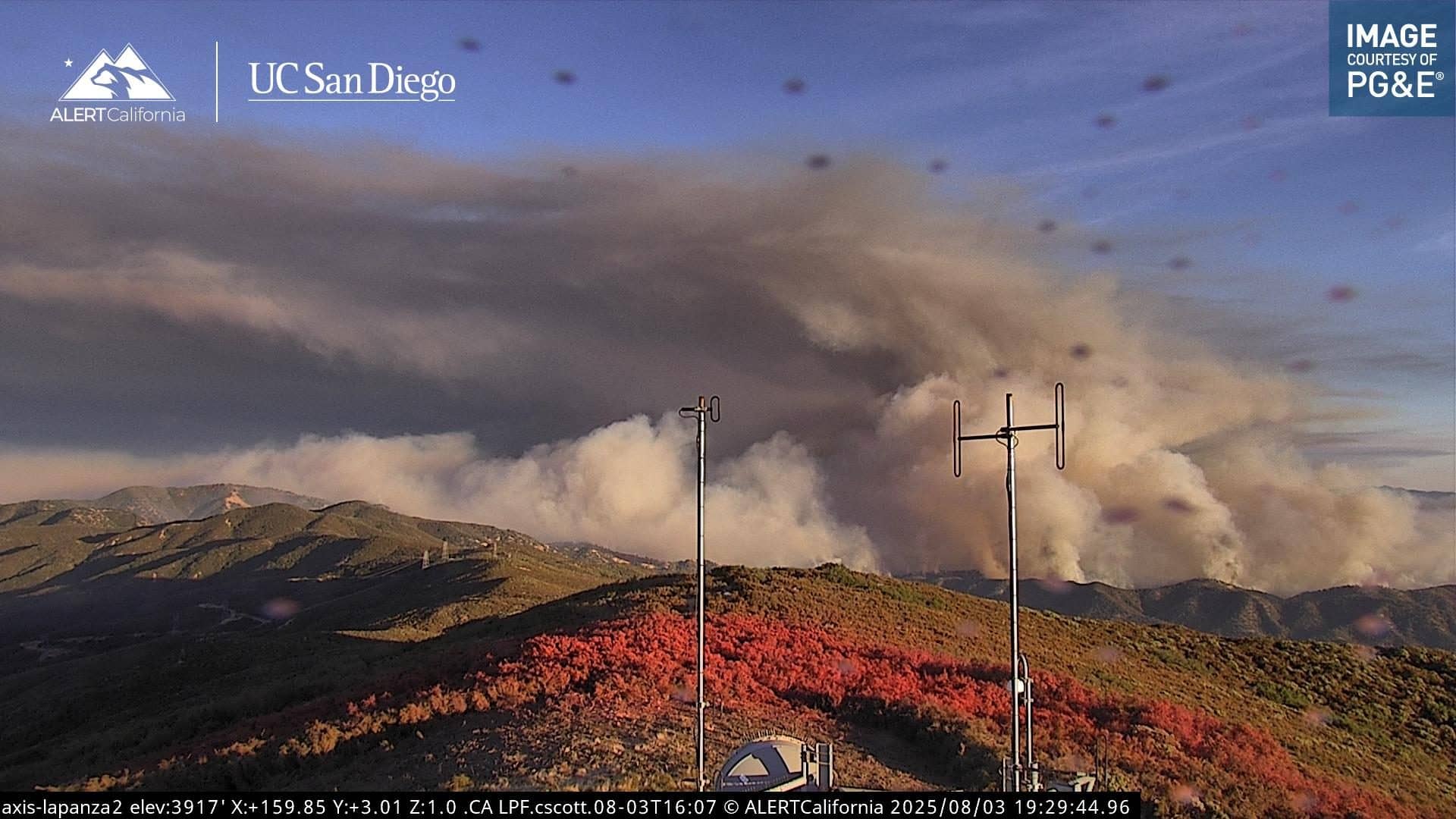
A wide shot provides a broader overview of the fire (courtesy: AlertCalifornia/PG&E/La Panza 2 Camera)
8/3/25 6:30PM UPDATE
Santa Barbara Evacuation zone SBC-169B has been upgraded to an EVACUATION ORDER. This includes the following areas:
School House Rd/Aliso Canyon
NORTH OF Sierra Madre Rd, Carrisa Hwy
SOUTH OF Highway 166
EAST OF School House Rd
WEST OF Aliso Canyon Rd
8/3/25 4:30PM UPDATE
An evacuation WARNING is out now for evacuation zone SLC-240 in San Luis County. This area includes:
North of Branch Mountain South of Gaviota/Dorrington Trail East of Branch Mountain and Apache Drive West of Keystone Trail and Sprague Hill Road
8/3/25 3:45PM UPDATE
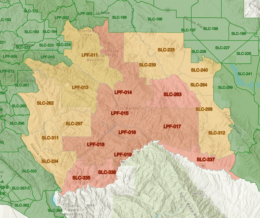
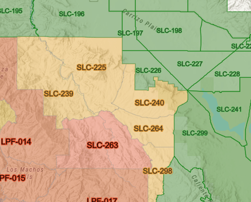
San Luis Obispo County – Evacuation Orders have been issued for Zones: LPF-014 & SLC-263 and Evacuation Warnings have been issued for Zones: LPF-011, LPF-013, SLC-225, SLC-239, SLC-262, SLC-264, SLC-298
8/3/25 – 10:30AM UPDATE
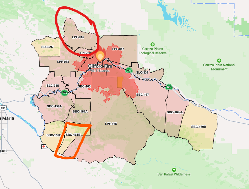
New acreage: 43,118
New evacuation order has been issued for San Luis Obispo County Zone, LPF-015
New evacuation warning for Santa Barbara County Evacuation Zone, SBC-161B which includes the following areas:
NORTH OF Tepusquet Rd
SOUTH OF Tepusquet Rd, Colson Canyon Rd
EAST OF Tepusquet Rd
WEST OF Carrisa Hwy, La Brea Canyon Rd
8/3/25 9AM UPDATE
The acreage of the Gifford Fire has increased to 39,676 with containment still at 5%. Overnight, the fire remained moderately active according to incident command. No new evacuation warnings or orders were issued overnight or as of this morning’s update.
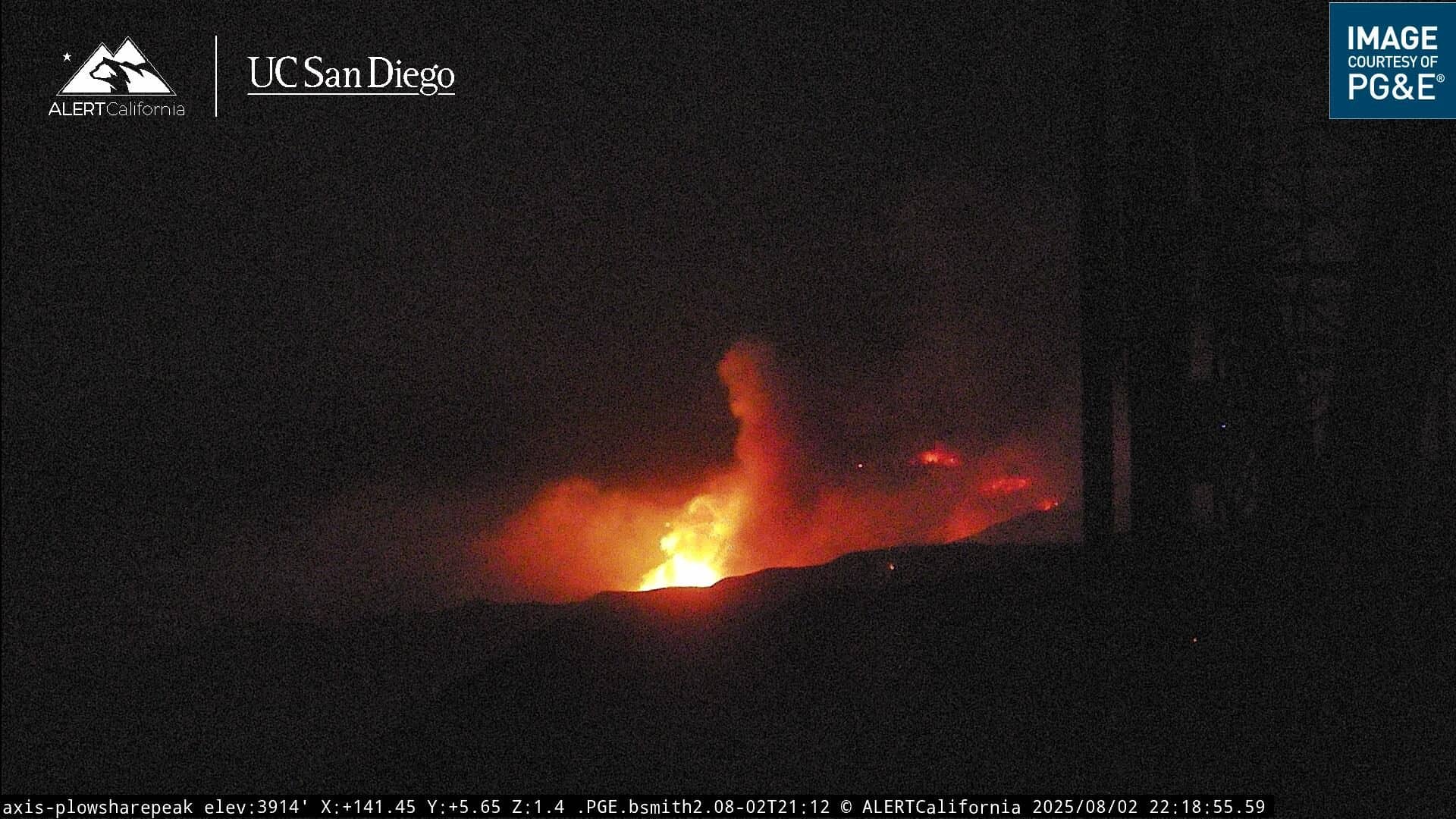
Courtesy: AlertCalifornia/PG&E/Plowshare Peak Camera. 10:18PM, Saturday Night 8/2. Flame activity from a south-easterly direction from location of camera.
8/2/25 10:15PM UPDATE
The Los Padres National Forest has released a briefing regarding the latest on the Gifford Fire. They provide some insight of the fire’s behavior, with most active flame fronts located steep and rugged terrain which is posing challenges for firefighting efforts. Currently, operations are running under a “unified command” in cooperation with the U.S. Forest Service, CAL FIRE, Santa Barbara County Sheriff’s Office and County Fire to help with protecting life, property and natural resources.
Three people have been injured as a result of the fire; a civilian who suffered burn injuries and two contractors who were hurt when their UTV rolled over. In the UTV rollover incident, one sustained moderate injuries and was rescued by helicopter and transported to Marian Regional Medical Center by air, the other victim only sustained minor injuries, and was able to go to the hospital via ambulance.
A federal incident management team are on their way to oversee management responsibilities for Gifford Fire operations.
8/2/25 5:50PM UPDATE
Acreage has been increased to 30,519. Containment remains at 5%. Santa Barbara County Office of Emergency Management confirms that a Temporary Evacuation Point is open at Benjamin Foxen Elementary School, 4949 Foxen Canyon Rd, Santa Maria for fire evacuees with American Red Cross staff on site to assist and provide information.
8/2/25 1PM UPDATE
NEW EVACUATION WARNINGS & ORDERS – SAN LUIS OBISPO COUNTY:
Here is an updated look at the evacuation warnings/orders for San Luis Obispo County.
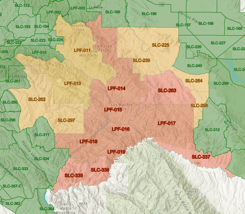
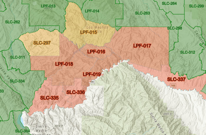
New Evacuation ORDER areas:
SLC-335, SLC-336 & LPF-018
New Evacuation WARNING areas:
LPF-015, SLC-297
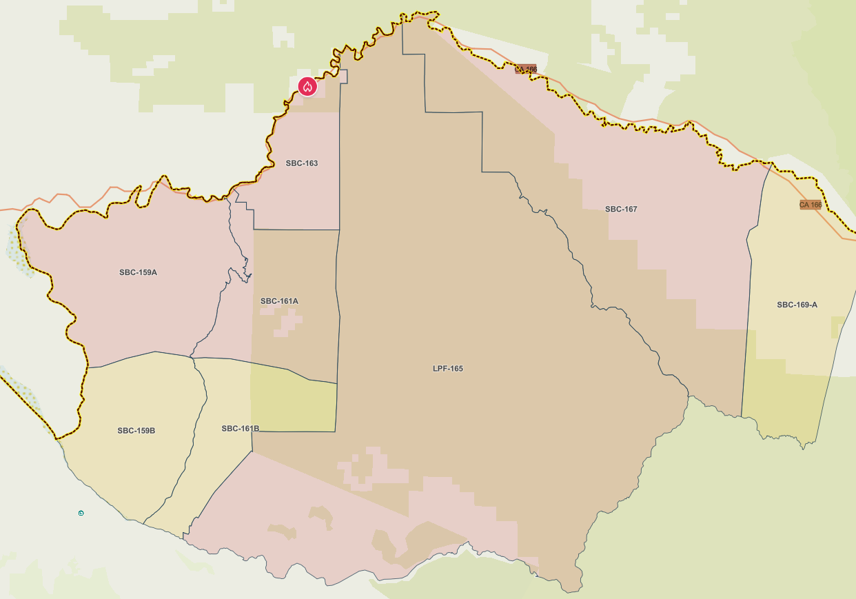
NEW EVACUATION WARNINGS & ORDERS – SANTA BARBARA COUNTY
This is the latest wide view of the current evacuation warnings and orders for Santa Barbara County. Below are specific areas in the zones
EVACUATION ZONE SBC-159A — EVACUATION ORDER:
NORTH OF: Colson Canyon Rd
SOUTH OF: Pine Canyon Rd, Tepusquet Rd, Highway 166
EAST OF: Tepusquet Rd
WEST OF: Carrisa Hwy.
EVACUATION ZONE SBC-161A — EVACUATION ORDER:
NORTH OF: Colson Canyon Rd SOUTH OF: Pine Canyon Rd, Tepusquet Rd, Highway 166 EAST OF: Tepusquet Rd WEST OF: Carrisa Hwy
EVACUATION ZONE SBC-159B — EVACUATION WARNING:
NORTH OF: Tepusquet Rd, Santa Maria Mesa Rd
EAST OF: White Rock Ln
WEST OF: Tepusquet Rd
EVACUATION ZONE SBC-161B — EVACUATION WARNING:
NORTH OF: Tepusquet Rd
SOUTH OF: Tepusquet Rd. & Colson Canyon Rd.
EAST OF: Tepusquet Rd
WEST OF: Carissa Hwy, La Brea Canyon Rd.
EVACUATION ZONE SBC-169A — EVACUATION WARNING
Cottonwood Canyon/School House Canyon
NORTH OF: Sierra Madre Rd
SOUTH OF: Highway 166
EAST OF: Cottonwood Canyon Rd/Foothill Rd
WEST OF: School House Rd/Wasioja Rd
Loading...
3628718186
Mozilla/5.0 AppleWebKit/537.36 (KHTML, like Gecko; compatible; ClaudeBot/1.0; +claudebot@anthropic.com)