

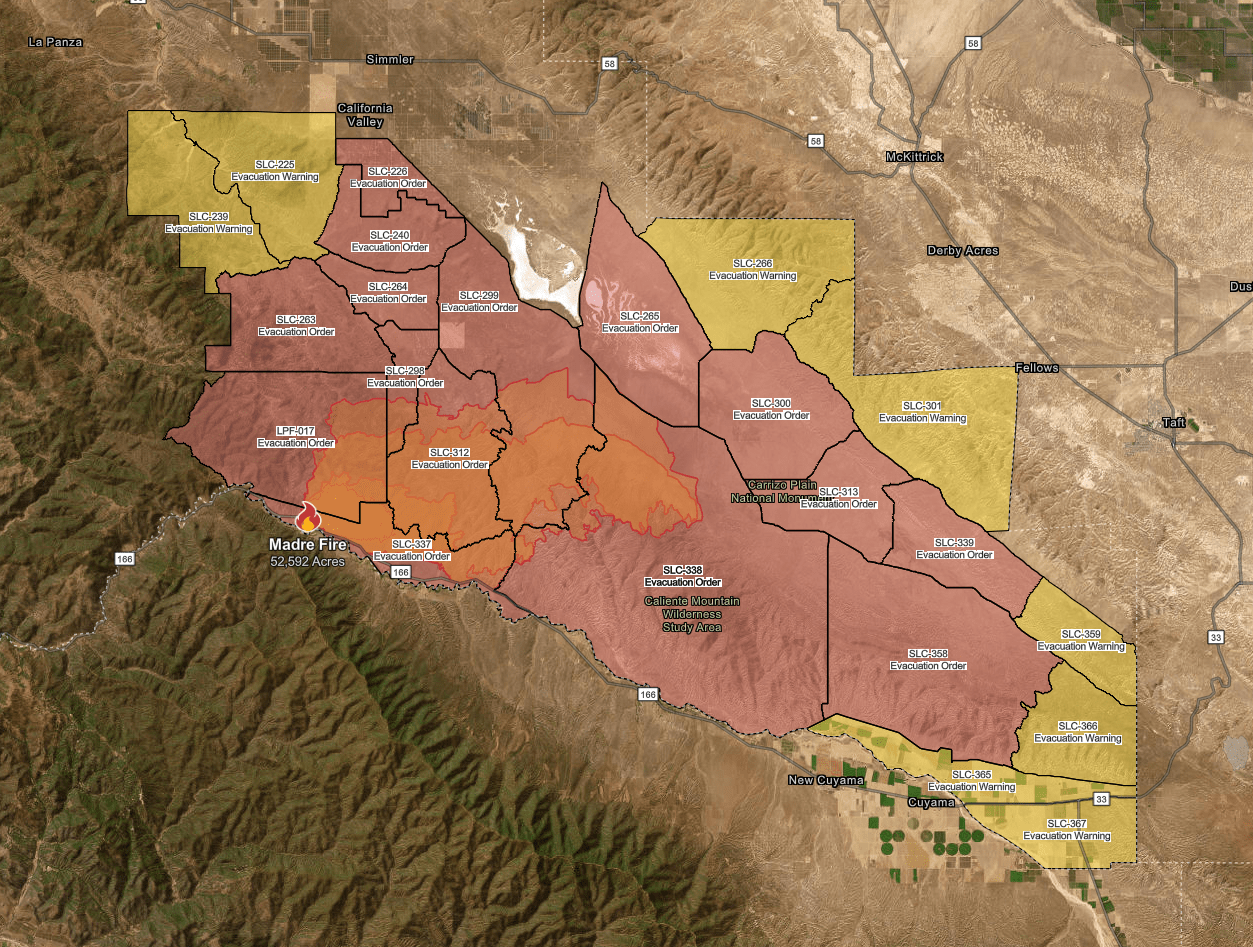
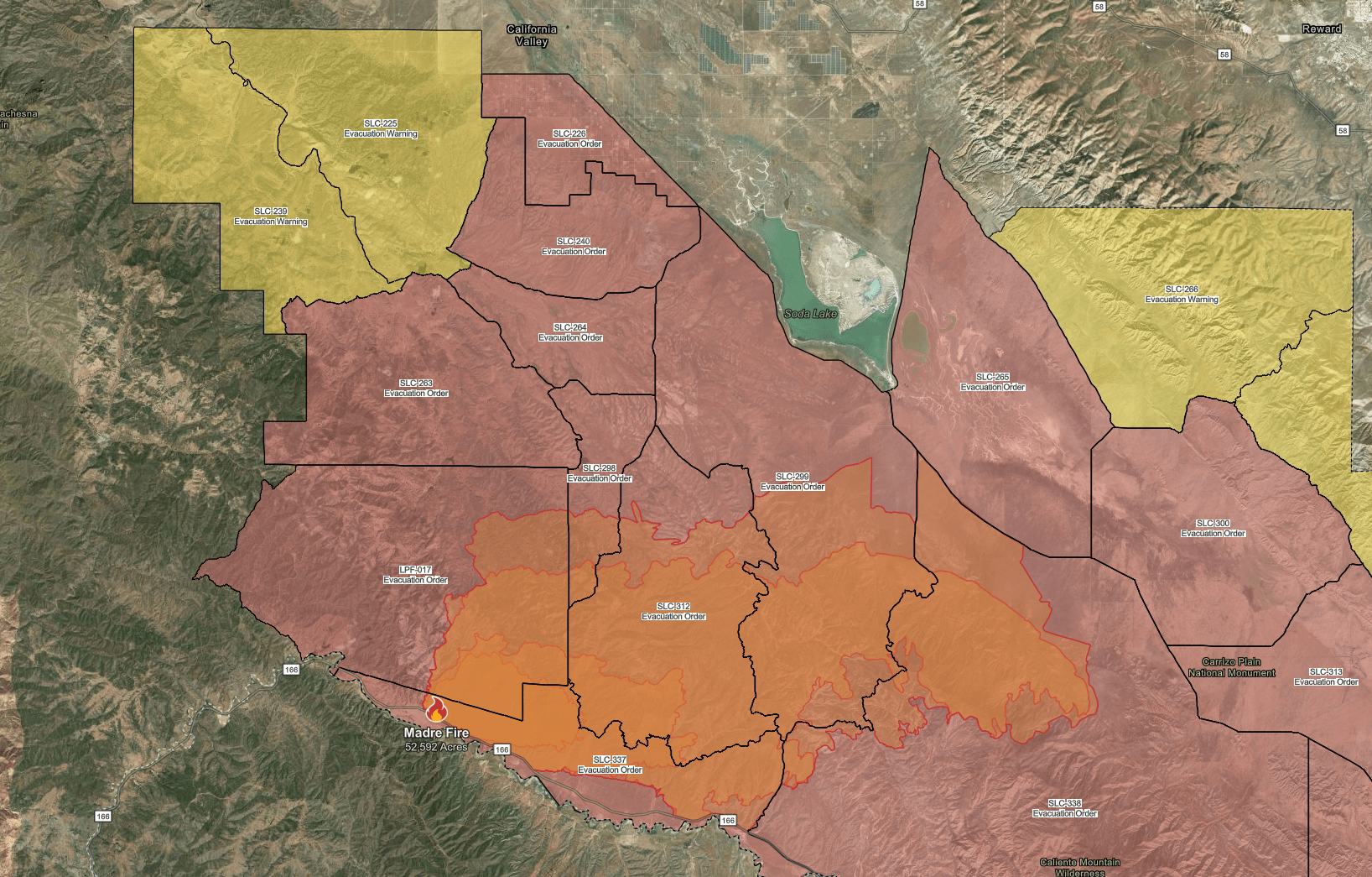
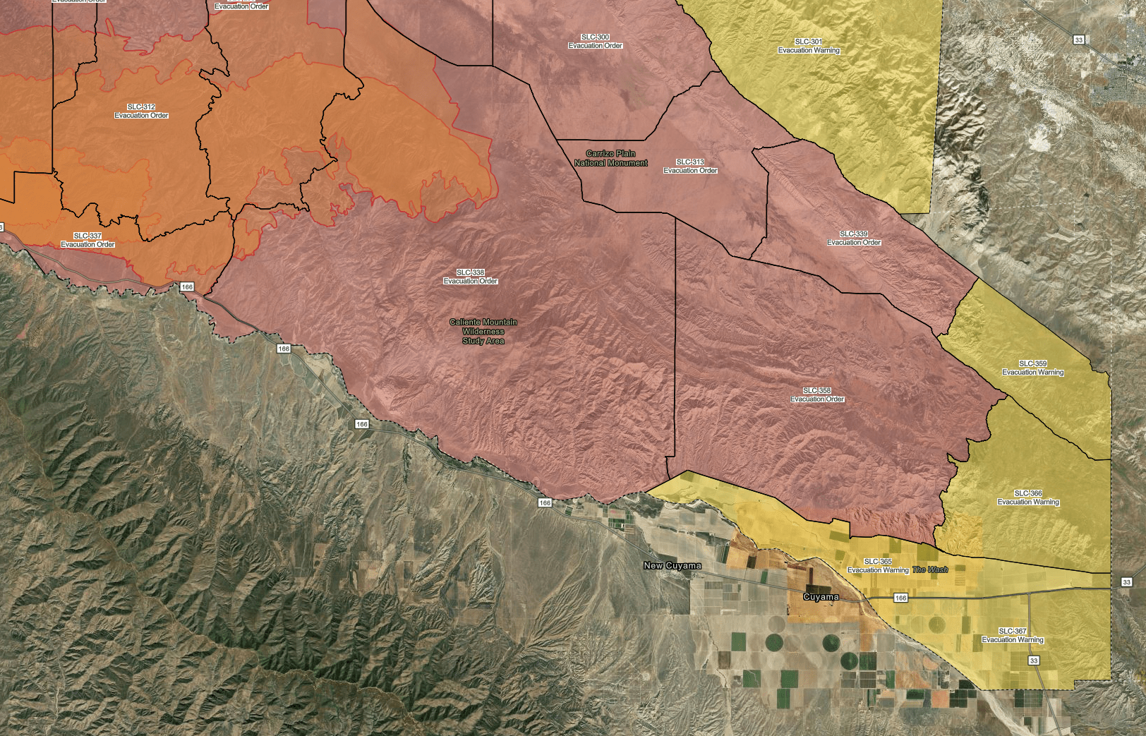
Click here to see a map of the current evacuation orders and warnings for County of San Luis Obispo
CURRENT ACREAGE: 80,480 | CONTAINMENT: 30%
7/6/25 8PM UPDATE
Acreage has been increased to 80, 480 with containment remaining at 30%. Minimal growth of the fire has occurred over much of the fire perimeter. Fire official report that in the northwest part of the fire, wind conditions have been more tamed and “favorable” for firefighting efforts. Overall the winds remained steady between 8-15mph most of the day with gusts 20-25mph. It is to be expected that similar conditions will persist tomorrow (Monday).
7/6/25 12:45PM UPDATE
Acreage has been upgraded to now just a little over 80-thousand acres.
8:30AM 7/6/25 UPDATE
Some good news this morning, containment has increased to 30%.
PAST UDPATES
10:30pm Update 7/5/25
Earlier Today, the Los Padres National Forest service issued a daily update. The acreage was brought up to 79, 936 with containment steady at 10%. They also reported that with how wind-driven the fire has been, this has made for increased growth of the fire in the southeast corridor of the fire perimeter, but also noted additional growth in the northwest part as well. Weather conditions the next day or so aren’t so much in the favor of firefighting efforts. Temperature still expected to climb to the mid 80s, high 90s with winds also increasing to 15-25mph from the southwest to the northwest and gusts probable up to 35mph, with the possibility of gusts up to 40 in the Antelope Valley foothills.
2PM UPDATE 7/5/25
CalTrans has confirmed that HWY.166 is now fully closed to the Kern & San Luis Obispo County line due to the Madre Fire.
7/5 Update at 12pm
Acreage increased overnight to 79,630; containment still remains at 10 percent.
7/4/25 6:15PM UPDATE
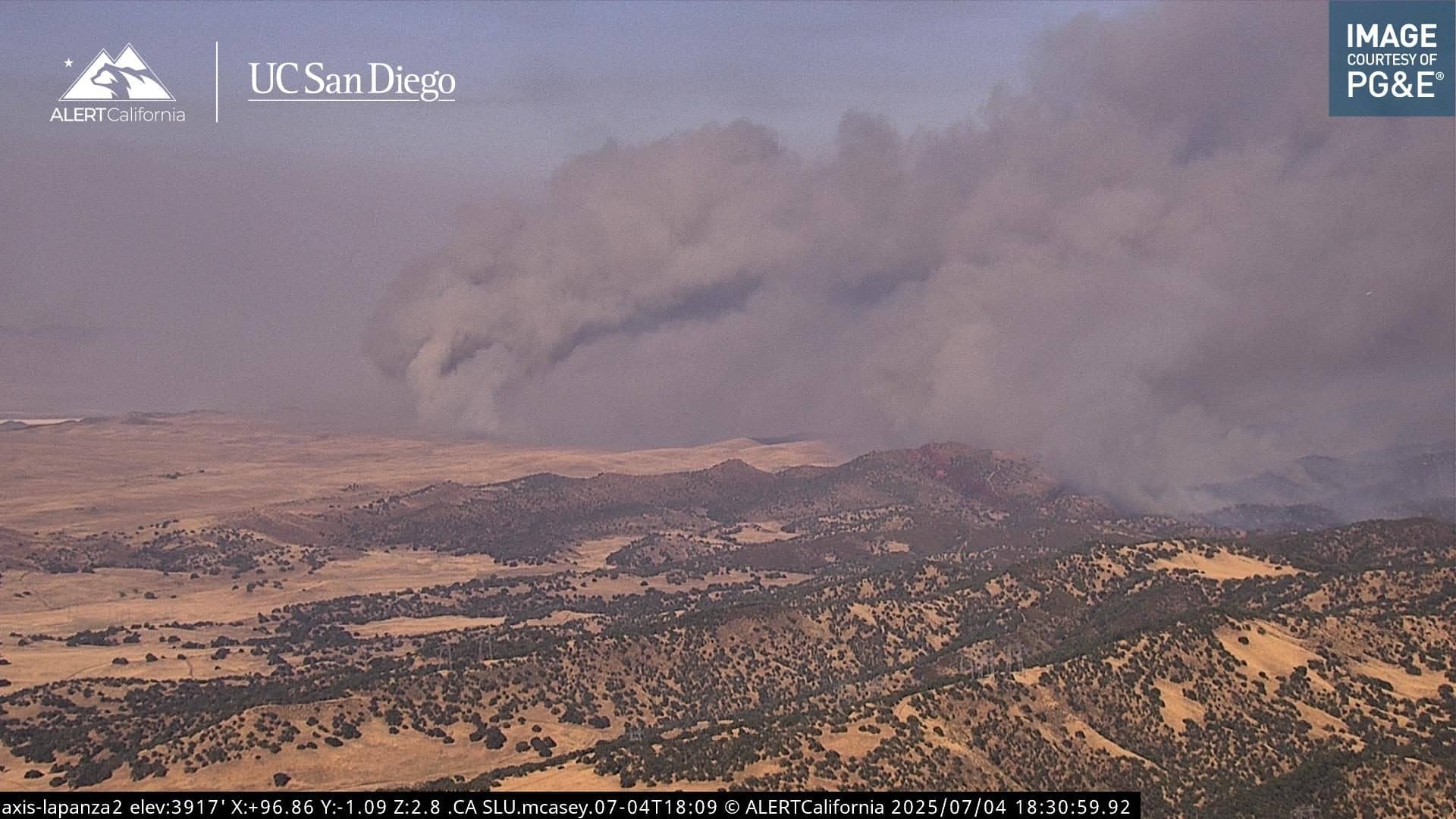
There are reports via radio traffic that indicate the fire has jumped San Diego Creek Rd., but not Soda Creek Rd. As it stands right now, this is confirmed to be the biggest fire this year so far in California. Here is a photo of the fire from AlertCalifornia
3:30PM UPDATE:
Acreage has increased to 70,800 Acres and containment still remains at 10%. There are reports that one outbuilding has been destroyed.
10AM UPDATE:
No new major updates to report. Containment and acreage remains the same with no new evacuation orders or warnings issued overnight. The fire still remains very active especially when certain topography along with just the right amount of fuels align.
Weather conditions will remain hot, mid 90s, throughout the weekend in the area of the fire; winds are forecast to decrease more so tomorrow. Humidity levels aren’t much in favor either in terms of helping with firefighting efforts. We’re likely going to be seeing humidity levels lower into the mid teens possible.
11PM UPDATE
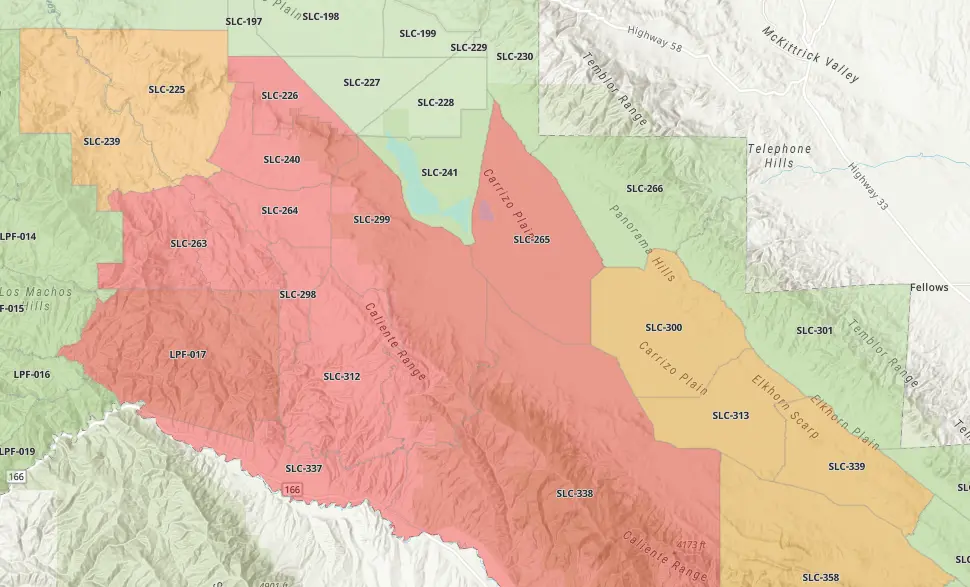
New Evacuation Warnings and Evacuation Orders for the following zones:
Evacuation ORDERS:
SLC-339, SLC-358
Evacuation WARNINGS:
SLC-266, SLC-301, SLC-359, SLC-365, SLC-366, SLC-367
The maps below indicate where these orders and warnings are located. Please click on photos for better viewing of areas. As of 11pm, evacuation warnings were now being extended into the Kern County area.
We’ll provide further updates in the morning.
9:20 UPDATE
New Evacuation Order now in effect for zones
SLC-300, SLC-313
See link above for the map showing this area.
8:30PM UPDATE
Containment has increased to 10%
5PM UPDATE:
New evacuation orders have been issued for the following areas: SLC-263, SLC-298, and SLC-240. This map is current as of 5pm Thursday, July 3.
Since yesterday, an evacuation WARNING remains in effect for the following area on the Santa Barbara County side of Highway 166: East of the Rock Front Area, West of Cottonwood Canyon Rd, and South of Highway 166. Temporary Evacuation Point has been set up at the CA Valley CSD – 13080 Soda Lake Rd, Santa Margarita, CA 93453.
The fire still remains at 5% containment with over 52 thousand acres burned so far.
The Bureau of Land Management has confirmed that all lands in the Carrizo Plain National Monument area have been closed to public access effective Thursday afternoon.